عضویت
عضویت  ورود اعضا
 راهنمای خرید


ENVI for Urban Planning0 pages

ENVI for
Urban Planning
Aerial and satellite imagery provide urban planners and public works officials with a bird’s eye view of the geography,
assets, and infrastructure of their communities. Geospatial imagery can be used to identify and categorize urban and
rural land use, map inventory for site selection applications, and assess the condition of public works assets.
The ENVI family of image analysis software provides best-in-class spatial and spectral tools needed to visualize and extract
information from these data sources, save time and money, and make more accurate decisions.
ENVI can be easily customized to solve your unique challenges, making it a highly flexible solution for urban and regional
planning applications. ENVI easily integrates into GIS workflows, allowing users to quickly and accurately view, manipulate,
process, and analyze imagery. And, because ENVI products are tightly integrated with ArcGIS®, you can easily exchange data
and layer files between the software packages.
Image Analysis Solutions for Urban Planning
Map and Monitor Land Cover
or Land Use
Land cover and land use categories can
be easily distinguished by analyzing
geospatial imagery using ENVI. You can use
the classification and feature extraction
tools in ENVI to map land cover or land use
from a wide variety of image types. And,
the change detection tools can be used to
monitor changes over time.
Radar and data fusion tools in ENVI are
especially useful when an area of interest
is inaccessible or obscured by clouds in
optical imagery.
Map and Monitor
Environmental Conditions
Using the tools found in ENVI, you
can derive information from imagery
that can help you map and monitor
pavement conditions, building materials,
desertification, deforestation, urbanization,
soil erosion, increase in impervious
surfaces, water loss, loss of farmland and/
or wilderness, and more. The information
extracted using ENVI can provide input to
environmental impact statements, land
development models, asset management
budgets, and more.
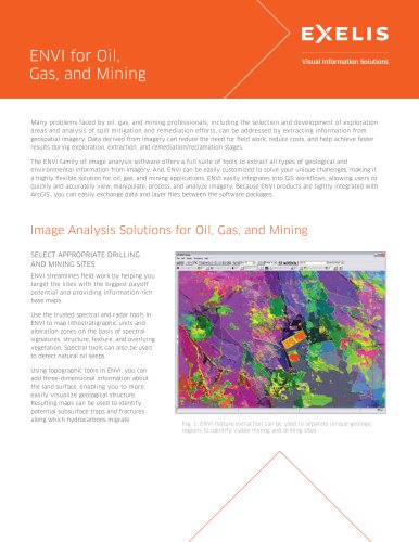
Fig. 1: ENVI’s feature extraction abilities are used by planners for asset
management and to analyze land use, building footprints, and utility
infrastructure.