عضویت
عضویت  ورود اعضا
 راهنمای خرید


ENVI for Agriculture and Forestry0 pages

ENVI for Agriculture
and Forestry
Many agricultural and forestry problems, such as determining crop health, insect infestations, and drainage patterns,
have traditionally been approached by performing extensive field work. These challenges can now be solved by deriving
information from geospatial imagery. This approach has several advantages, including reduced costs and faster results.
The ENVI family of image analysis software offers a full suite of tools to extract all types of vegetation-related
information from any type of imagery. And, ENVI can be easily customized to solve your unique challenges, making it a
highly flexible solution for agricultural and forestry applications.
ENVI easily integrates into GIS workflows, allowing you to quickly and accurately view, manipulate, process, and analyze
imagery. Because ENVI products are tightly integrated with ArcGIS®, you can easily exchange data and layer files
between the software packages, saving you time and effort.
Image Analysis Solutions for Agriculture and Forestry
Map and Monitor Land Cover
or Land Use
Vegetation indices in ENVI can be used to
detect greenness, light use efficiency, canopy
nitrogen, dry or dead vegetation, specific
pigments, and canopy water content. Tools
in ENVI are designed to identify areas in
agricultural fields that are under stress and
need your additional attention. Additional
tools can identify pest and blight conditions
and assess areas of timber harvest.
Map and Monitor the Effects of
Clear Cutting or Deforestation
ENVI and geospatial imagery can help you
to determine the effects of clear cutting and
deforestation. ENVI can also be utilized to map
and assess forest health by analyzing mature,
thinned, cleared, and regenerating forests.
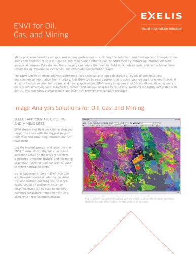
Fig. 1: ENVI provides intuitive, automated tools for performing
advanced processes on hyperspectral, multispectral, and
panchromatic data to visualize agriculture and forest regions.