عضویت
عضویت  ورود اعضا
 راهنمای خرید


ENVI for Oil, Gas, and Mining0 pages
ENVI for Oil,
Gas, and Mining
Many problems faced by oil, gas, and mining professionals, including the selection and development of exploration
areas and analysis of spill mitigation and remediation efforts, can be addressed by extracting information from
geospatial imagery. Data derived from imagery can reduce the need for field work, reduce costs, and help achieve faster
results during exploration, extraction, and remediation/reclamation stages.
The ENVI family of image analysis software offers a full suite of tools to extract all types of geological and
environmental information from imagery. And, ENVI can be easily customized to solve your unique challenges, making it
a highly flexible solution for oil, gas, and mining applications. ENVI easily integrates into GIS workflows, allowing users to
quickly and accurately view, manipulate, process, and analyze imagery. Because ENVI products are tightly integrated with
ArcGIS®, you can easily exchange data and layer files between the software packages.
Image Analysis Solutions for Oil, Gas, and Mining
Select Appropriate Drilling
and Mining Sites
ENVI streamlines field work by helping you
target the sites with the biggest payoff
potential and providing information-rich
base maps.
Use the trusted spectral and radar tools in
ENVI to map lithostratigraphic units and
alteration zones on the basis of spectral
signatures, structure, texture, and overlying
vegetation. Spectral tools can also be used
to detect natural oil seeps.
Using topographic tools in ENVI, you can
add three-dimensional information about
the land surface, enabling you to more
easily visualize geological structure.
Resulting maps can be used to identify
potential subsurface traps and fractures
along which hydrocarbons migrate.
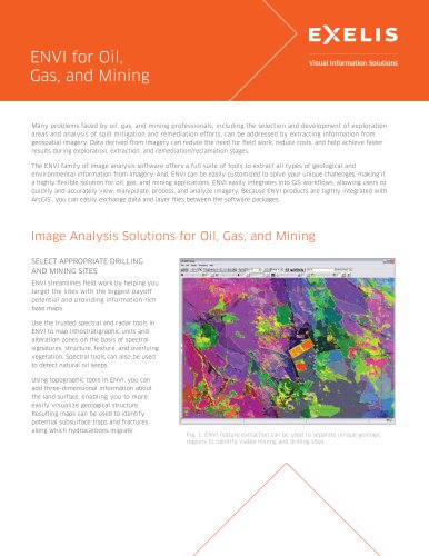
Fig. 1: ENVI feature extraction can be used to separate unique geologic
regions to identify viable mining and drilling sites.