عضویت
عضویت  ورود اعضا
 راهنمای خرید


EXPLORATION SEISMOGRAPH 16S_N0 pages
Via Galliari 5/E
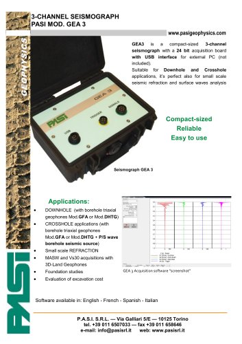
P.A.S.I. Seismograph Mod.16S24-N
10125 Torino - Italy
Phone +39 011 6507033
FAX +39 011 658646
info@pasisrl.it
www.pasigeophysics.com
P.A.S.I. seismograph Mod. 16S24-N is not only characterized by its innovative design
and its completely renewed acquisition software. With the possibility to be implemented with the 16G electrical imaging system, so to have, combined in the same instrument, two powerful and sophysticated systems for a detailed environmental analysis)
it really becomes the reliable solution for yours field applications.
Thanks to the large 10.6” LCD touch screen, the user interface results particularly
immediate and complete at the same time.
July 2012
Available Models
The logical steps proposed for setting each kind of profile (refraction, reflection,
MASW, microtremors, downhole, etc..) by the sophisticated acquisition software will
allow the user to always take the situation under control.
Mod.16S24-N (24 channels)
All data are then saved on the internal hard disk, ready for a fast transfer to PC via
USB for the subsequent data processing.
Mod.16SG24-N (combined
system electrical imaging +
24 channel seismograph)
Finally, the integrated “DOWNHOLE” software module, which is fundamental for
facilitating this particular kind of acquisition (also refer also to DHTG borehole geophone description), is an important value added factor for the instrument.
12 channel versions available
on request
Applications
Available accessories
3D Borehole geophone
DHTG50 (50m of cable) &
DHTG100 (100m of cable)
Seismic cables (different
length and spacing available
on request)
Vertical & horizontal geophones
Hydrophones
Striking plate for P & S waves
Geological stratigraphy at small and medium depth
Depth and geometry determination of bedrock
determination of Vs30 profile according to the new antiseismic regulations
(MASW, microtremors, downhole, ecc..)
Detailed investigations
sliding surface
Foundation studies
on
landslides
for
the
Preliminary investigations for the realization
(railroads, roads, oil pipelines)
Cost estimation for excavation and earth levelling
Evaluation of gravel, sand, clay deposits
Mineral exploration
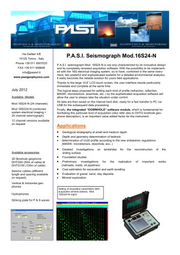
Setting of acquisition parameters (left);
acquisition window (below); Mod.
16SG24-N (right)
reconstruction
of
important
of
the
works
"