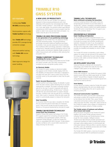
عضویت
عضویت  ورود اعضا
 راهنمای خرید


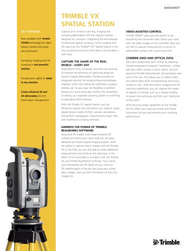
Trimble VX0 pages
DATASHEET
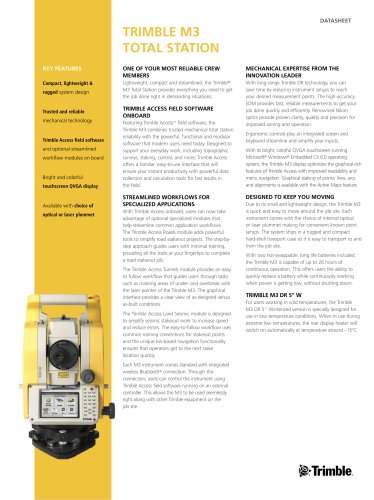
TRIMBLE VX
spatial station
Key Features
Now available with Trimble
VISION technology for video
robotic control and scene
documentation
Surveying, imaging and 3D
scanning in one powerful
solution
Increase your agility to adapt
to any situation
Create enhanced 2D and
3D deliverables for rich
information management
Capture and combine scanning, imaging and
surveying deliverables with the singular solution
designed for surveyors. Integrating the technologies
of advanced optical surveying, metric imaging and
3D scanning, the Trimble® VX™ Spatial Station is the
only surveying instrument that does it all and does it
with ease.
Video-Assisted Control
Trimble VISION™ gives you the power to see
everything the instrument sees. Direct your work
with live video images on the controller. Now you
are free to capture measurements to prism or
reflectorless surface with a point and click.
Combine GNSS and Optical Data
Capture the shape of the real
world – every day
Expectations from surveying customers are evolving.
To improve the efficiency of capturing advanced
Spatial Imaging deliverables, Trimble provides an
integrated solution for bringing these technologies
together within the traditional workflows surveyors
already use. So you have the flexibility to perform
feature-rich scans every day, without the complexity
of setting up a separate scanning system or switching
to specialized field software.
With the Trimble VX Spatial Station, you can
efficiently capture the information you need to create
digital terrain models (DTMs), volume calculations,
and perform topographic measurements faster than
with traditional surveying methods.
Harness the Power of Trimble
RealWorks software
Advanced 3D models and image-rendered 3D
surfaces are within your reach with the rich data
delivered by Trimble Spatial Imaging sensors. With
the ability to capture metric images with the Trimble
VX in the field, you are also able to make additional
measurements and attribute the data back in the
office. It’s all accessible to surveyors with the Trimble
VX and Trimble RealWorks® software. Your clients
will immediately see the detail of your work via
3D walkthroughs of the job site using your survey
data, images, and scanned information all from the
Trimble VX.
Take your productivity even further by adopting
Trimble Integrated Surveying™ workflows – simply
add your GNSS receiver to your robotic rod and
powerful Trimble field software will seamlessly take
care of the rest. This allows you to collect GNSS
and optical data while simultaneously scanning a
surface or site. With the built-in imaging and 3D
scanning capabilities, you can capture the shape
of objects of interest, such as a nearby building
or power lines while you perform your traditional
survey work.
With the long range capabilities of the Trimble
DR Plus EDM, you measure further with fewer
instrument set-ups and enhance your scanning
performance.