عضویت
عضویت  ورود اعضا
 راهنمای خرید


ENVI for Environmental Conservation Management0 pages

ENVI for Environmental
Conservation Management
Many environmental managers and conservation programs are now taking advantage of increasingly available geospatial
imagery to address problems that range from monitoring the effects of pollution to identifying optimal locations for
planting trees. Traditionally, these challenges have required more expensive, time-consuming visits to the field. Reduced
costs and faster results are just some of the benefits that can be achieved by extracting information from imagery.
The ENVI family of image analysis software provides a full suite of tools to address environmental issues related to
forests, fisheries, habitats, biological diversity, materials conservation, energy conservation, and other related fields.
And, ENVI can be easily customized to solve your unique challenges, making it a highly flexible solution for environment
and conservation applications.
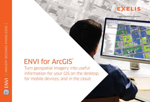
ENVI easily integrates into GIS workflows, allowing users to quickly and accurately view, manipulate, process, and analyze
imagery. Because ENVI products are tightly integrated with ArcGIS®, you can easily exchange data and layer files between
the software packages.
Image Analysis Solutions for Environmental Conservation Management
Map Land Cover and Wetlands and
Detect and Monitor Change Over Time
Land cover and wetlands categories are easily
distinguished and classified by processing geospatial
imagery using ENVI. In addition, you can use change
detection tools in ENVI to detect and assess the areas
and percentages of all types of changes, including urban
development, deforestation, shoreline erosion, and
restoration/remediation efforts.
Map and Assess Forest Health
and Protected Areas
Forest health and the success of protected areas are
easily mapped and assessed using ENVI. Feature
extraction and classification tools in ENVI can be used
to distinguish mature, thinned, cleared, and regenerating
forests, while change detection tools can help you
assess the state of forests, and other protected areas
before and after clear cutting, deforestation, and other
environmental conditions.
Fig. 1: ENVI helps you create maps of the watering needs of
agricultural or landscaped areas.