عضویت
عضویت  ورود اعضا
 راهنمای خرید


Headwall's Airborne Solution0 pages

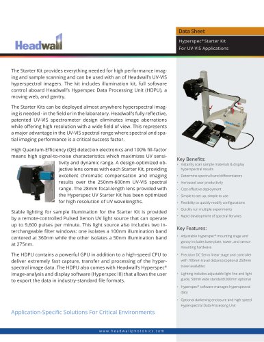
Data Sheet
Integrated Hyperspec®
Imaging Solution
Headwall provides a complete and fully integrated
airborne solution comprising GPS/INS, data-processing, and applications software.
For airborne remote sensing applications, Headwall brings together a
completely integrated package designed to work with your choice of
Hyperspec® sensor. The package includes GPS/INS functionality (LiDAR
optional), integrated data-processing hardware, and Headwall’s Hyperspec III airborne applications software that manages the operation of
the sensor throughout flight. The entire
package has been optimized for small size
and light weight, and all elements are fully
integrated.
Headwall offers both multi-rotor and fixedwing UAV solutions to meet a very broad
range of application needs.
Headwall’s Micro-Hyperspec® sensors address the need for very small, lightweight,
and robust hyperspectral imaging instruments capable of being deployed in harsh
environments. The sensors are particularly well suited for applications where high
spectral/spatial resolution and high dynamic range are key performance parameters. Micro-Hyperspec® G-Series covers
the 400-1000nm VNIR spectral range; other versions are also available for the NIR
(900-1700nm), Extended VNIR (550-1700nm) and SWIR (950-2500nm)
ranges. Headwall’s patented aberration-corrected optics assure best
resolution, high signal to noise and flight-path efficiency thanks to a
very wide field-of-view.
Headwall also provides complete hyperspectral data-processing as
part of the overall airborne package. This includes the advanced Hyperspec III software, which manages sensor control and all incoming
hyperspectral data. Headwall also has an on-line map-based ‘Polygon
Tool’ that allows users to select the parameters for sensor operation
while aloft.
Application-Specific Solutions For Critical Environments
www.headwallphotonics.com
Micro Hyperspec® Sensor
Integrated GPS/INS & optional
LiDAR
Airborne Application Software
"